
A. Sutherland – AncientPages.com – Since antiquity, the Egyptian civilization has depended on the Nile River, relying heavily on its annual floods for sustenance and prosperity.

Nilometer on the southeast side of Elephantine Island in Aswan, Egypt. Imagec redit: Olaf Tausch – CC BY 3.0
Without the Nile River, the country could not exist. The Nile was the foundation of life, and at the same time, the basis of the ancient Egyptians’ religion, work, food production and the calendar.
But the Nile’s flooding was unpredictable. High floods could devastate settlements surrounding the river, while low floods reduced or destroyed crop yields and caused diseases.
The Nile: 2.19-34
19. “So said the oracle. Now the Nile, when it overflows, floods not only the Delta, but also the tracts of country on both sides the stream which are thought to belong to Libya and Arabia, in some places reaching to the extent of two days’ journey from its banks, in some even exceeding that distance, but in others falling short of it…” (Herodotus)
Therefore, during the Pharaonic Period, the ancient Egyptians employed a systematic approach to measure the Nile’s water levels. This method, combined with the use of the nilometer, allowed them to make remarkably accurate predictions about the forthcoming harvest.

Nilometer of Kom Ombo Temple, Egypt. Image credit: Celio Maielo – CC BY-SA 3.0
The nilometer was an ingenious device that was a crucial indicator of the Nile’s water levels. Based on current observations, it enabled predictions regarding the forthcoming season’s water levels.
The simplest design was a vertical column submerged in the river with marked intervals indicating depth. Another design was a flight of stairs leading into the river.
The nilometer data was then used by the ancient Egyptian priesthood, who ‘mysteriously’ predicted when the flood would occur by monitoring the day-to-day level of the Nile River.
One unique and historic structure is located on Rhoda Island in central Cairo. It was constructed in 861 AD on the exact location of a much older structure of this kind.

Cairo Nilometer – measuring shaft of the Nilometer on Rhoda Island, Cairo. Image credit: Berthold Werner – CC BY-SA 3.0
These water measurement structures continued to be useful until the modern era, when large water storage reservoirs disrupted the Nile’s natural flows.
Another historically important nilometer is located on the island of Elephantine in Aswan. In fact, the island Elephantine has two nilometers, each associated with its respective deity and temple.
The two structures exhibit different architectural configurations. Khnum’s nilometer was built as a square basin, deviating from the conventional design.

Nilometer on Elephantine Island. Aswan, Egypt. Image credit: Hajor – CC BY-SA 3.0
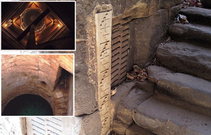
This is probably one of the most interesting structures on the island and one of the earliest known nilometers used by ancient people. From the entrance, 90 steps lead steeply down to the river, with depth markings along the walls.
Elephantine marked Egypt’s southern border and was the first place where the onset of the annual flood was detected. The most elaborate design involved a channel or culvert leading from the riverbank, often running for a considerable distance, and then feeding a well, tank, or cistern.
These nilometer wells were most frequently located within the confines of temples, where only the priests and rulers were allowed access.
In contrast, Satet’s nilometer has a much more traditional design. It has a staircase going with measuring holes in its walls, all the way down to the river.

Nilometer on Elephantine Island, Egypt. Image credit: Szabolcs Gebauer
Also, the Edfu Temple complex had once its nilometer. Access to this remarkable structure leads through a subterranean staircase, originating from the eastern side of the Inner Passageway. Currently, it is disconnected from the Nile but the shaft itself still remains visible.
Egypt’s ancient nilometers served people for a very long time, and continued to be used by later civilizations until the 20th century.
The survival and prosperity of the ancient Egyptian civilization were undeniably dependent upon the presence of the Nile River. This majestic watercourse provided the people’s survival and wealth and contributed to the development of a sophisticated society – one of the most influential civilizations in human history.
Today, the nilometers are considered somewhat obsolete. The Aswan Dam primarily aims to regulate the flow of the River Nile, which serves as a lifeline to almost all of Egypt.
Written by – A. Sutherland – AncientPages.com Senior Staff Writer
Expand for references