
Jan Bartek – AncientPages.com – The ancient city of Alexandria (Charax), once a thriving metropolis on the Tigris River, is not widely known today. However, this may soon change due to recent discoveries by a team of archaeologists who have pinpointed its location and uncovered evidence of its role as a center for ancient long-distance trade.

Location of Alexandria/Charax. Credit: Stefan R Hauser, University of Konstanz
Led by archaeologist Stefan Hauser from the University of Konstanz, the research team has shared new insights into this remarkable site and outlined future archaeological plans that could further illuminate the history of this lost city.
Beginning With Alexander The Great, Who Needed A New Port
Alexandria’s origins trace back to the 4th century BC, following Alexander the Great’s conquest of the Achaemenid Persian Empire. After returning from his campaign along the Indus River, Alexander sought to travel by sea from Susa, the capital of the Achaemenid Empire, to Babylon. It was during this time that he recognized the strategic need for a new port.
According to Professor Stefan Hauser, detailed historical accounts by participants in Alexander’s campaigns provide valuable information about these events. These findings offer an exciting opportunity to deepen our understanding of both Alexandria on the Tigris and its significance in ancient history.
Southern Mesopotamia experienced significant changes due to sedimentation, a process in which alluvial material carried by the Tigris and especially the slower-moving Euphrates rivers was deposited. Over time, this led to the coastline of the Persian Gulf receding further inland, transforming areas that were once part of the sea into land. In response to these changes, a new port city—Alexandria on the Tigris—was established at a strategic location where the Karun River from Susa joined with the Tigris, about 10 stadia (approximately 1.85 kilometers) from what was then the sea.
The Ancient City Was Known As Charax Spasinou Or Charax Maishan
This city later became known as Charax Spasinou or Charax Maishan and is referenced by Roman authors as well as inscriptions found in Palmyra. However, much about its fate remains uncertain today.

Still impressive today: the city walls of Alexandria. Credit: Charax Spasinou Project (Stuart Campbell 2017)
In an effort to uncover more information about this ancient settlement, John Hansman analyzed aerial photographs taken by the Royal Air Force in the 1960s while researching river changes during Islamic times for his doctoral thesis in London. He identified a kilometer-long rampart and traces of a settlement that matched Pliny the Elder’s first-century AD description of Alexandria/Charax. Despite these promising findings, Hansman’s identification remained hypothetical after only a brief site visit.
Further research has been challenging for several reasons. As Stefan Hauser explains, not only did Alexandria/Charax flourish during periods often overlooked by historians and archaeologists, but its location—now called Jebel Khayyaber—is just 15 kilometers from Iran’s border. This area became a major battleground during the First Gulf War between Iran and Iraq in the 1980s; subsequently, military camps were established among its ruins. These factors have made comprehensive archaeological investigation difficult up to now.
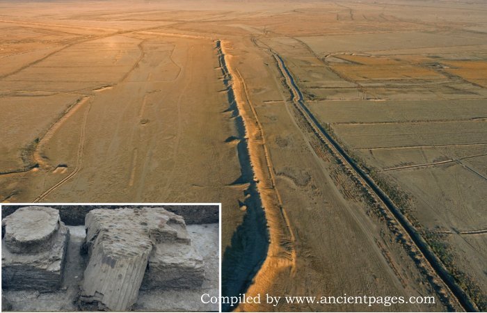
Foreign archaeological expeditions did not enter the country until 2014, when British archaeologists Jane Moon, Robert Killick, and Stuart Campbell—who were already working at a site near Ur—were invited by the head of the Antiquities Authority in Basra to visit another location: Jebel Khayabber.
In accordance with prevailing safety protocols, they traveled 50 kilometers to the site in heavily armored vehicles. Upon arrival, they were struck by the impressive scale of a kilometer-long rampart that still rises to a height of up to 8 meters. It was only on their return journey that they realized that this vast, mostly flat ruin was, in fact, the renowned foundation attributed to Alexander the Great.
In spring 2016, a three-week British excavation campaign commenced at Jebel Khayabber. Soon after, recognizing their need for expertise in Hellenistic archaeology—a period outside their usual focus—the team enlisted Stefan Hauser, one of the world’s leading specialists in Near Eastern archaeology during this era.
A Model Of The Ancient Alexandria (Charax) Metropolis
When Hauser and his team first arrived in the region in 2017, much of northern Iraq and Syria remained under the control of the Islamist terrorist group known as the “Islamic State.”
As a result, security conditions across the country were unstable. The archaeologists were restricted to conducting only surface investigations and were required to be accompanied at all times by soldiers or police officers; leaving their camp without such an escort was not permitted.
Over time, they surveyed more than 500 kilometers of surrounding terrain, meticulously documenting all surface finds—such as pottery shards and broken bricks—that provided evidence of past settlements. By analyzing thousands of drone images, they constructed a detailed terrain model and discovered that Alexandria on the Tigris had once been an extensive metropolis.
“We now realize that we truly have the equivalent of Alexandria on the Nile, the famous city in Egypt. The situation is essentially the same: a city founded where the open sea and the river systems—the main transport routes into the interior—meet. Alexandria on the Tigris must have perfectly fulfilled its role as one of the central hubs of ancient long-distance trade for over 550 years,” Professor Hauser explained in a press release.
Scientists Successfully Mapped The City Using Advanced Geophysical Techniques
Geophysicist Jörg Faßbinder of Munich conducted the initial exploration using a cesium magnetometer to noninvasively detect walls, ditches, and hearths by measuring subtle changes in the Earth’s magnetic field. Assigning color values to these measurements produced images that clearly revealed streets and walls, including some of the largest ancient city blocks known. In subsequent years, Campbell and later Hauser continued geophysical surveys of the city with support from the Gerda Henkel Foundation and Eastern Atlas.
“We quickly realized that a large part of the city was laid out systematically. Even two kilometers south of the northern city wall, we see streets and blocks of houses arranged exactly parallel to it. The city’s structure must therefore have followed an overall plan,” Professor Hauser said. However, the archaeologist also notices deviations in the grid: “Within enormous blocks of houses, we sometimes see building complexes that overlap other walls and are shifted relative to the grid, so they probably date from a later phase of the city.”

Credit: Charax Spasinou Project 2022 (Robert Killick)
The presence of four distinct grid orientations in Alexandria/Charax reveals more than just different construction phases; it also points to varied functional zones within the city. The site included a substantial residential area that housed several large temple complexes. Numerous workshops, such as kilns and smelting furnaces, were situated near an inner-city port and canal system, indicating a hub of industrial activity.
According to Professor Hauser, another section featured a palace-like complex without adjacent roads, which may suggest the existence of parkland or areas dedicated to urban agriculture. Additionally, he believes that grain fields were likely located north of the city, where satellite imagery has identified an extensive irrigation system integrated into the urban plan.
Why And When Was Alexandria/Charax Abandoned?
Between 300 BC and 300 AD, the city of Alexandria/Charax played a significant role in the intensification of long-distance trade routes connecting Mesopotamia with India, Afghanistan, and China. During this period, major urban centers such as Seleucia and Ctesiphon emerged south of present-day Baghdad on opposite banks of the Tigris River. These cities served as successive capitals for the Seleucid Empire and, from 141 BC onward, the Arsacid (Parthian) Empire. Their strategic locations contributed to their prominence in regional politics and commerce.
“Apparently, the Euphrates became marshy in its southern part. With the founding of Alexandria/Charax and, shortly thereafter, Seleucia, the Tigris became the main connection between north and south. The Euphrates, and thus the old capital Babylon—which still remained a large city—lost its importance,” Hauser reconstructs the situation. Capitals like Seleucia housed not only powerful rulers and their courts but also large populations. Ancient authors of the 1st and 2nd centuries AD attributed 400,000–600,000 inhabitants to Seleucia alone, making it a huge market for goods from India.
Alexander founded Alexandria on the Tigris to serve as a port and distribution center for trade with India. Indeed, all goods traffic probably passed through this city. Even when new ports were built farther south as the river silted up, this remained the main transshipment point,” explains Professor Hauser.

Image of a city district featuring residential buildings and temple complexes, obtained using a cesium magnetometer. Credit: Charax Spasinou Project 2016 (Jörg Fassbinder)
The dramatic difference between the vibrant trading metropolis that once thrived and its submerged ruins today is undeniable. But what caused such a significant decline? According to Professor Hauser, Alexandria’s prosperity was deeply tied to its access to the river—a lifeline for its economy. When the Tigris River unexpectedly shifted westward at some point in history, this essential connection was severed, leading to the city’s downfall.
To uncover the full story behind these environmental changes, Professor Hauser collaborated with a geologist for drilling operations and enlisted an expert in geophysical data analysis. Their combined efforts provide compelling evidence that shifts in natural landscapes can profoundly alter human destinies.
See also: More Archaeology News
“The settlement was probably largely abandoned in the 3rd century AD,” confirms Professor Hauser.
“By that time, it likely no longer lay on any river and, as ancient sources tell us, the progressive silting of the southern shoreline had left it 180 kilometers from the Persian Gulf. The town lost its importance as the capital of the northern Gulf region and as a trading center, and was eventually abandoned altogether. Its modern successor is the city of Basra.”
Written by Jan Bartek – AncientPages.com Staff Writer